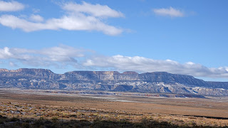
Crossing Arizona and the Navajo Reservation on Highway 160 is always a treat. This very scenic road passes the Four Corners Monument, the road to Canyon de Chelly, the road to Monument Valley and the road to all the incredible features near Page. In between these points is some great red rock scenery that always frustrates me because it is mostly off limits to visitors. With few places to pull off, even distant photos can be really difficult to get. Since there was little traffic this day, I was able to get a few photos by stopping in the middle of the highway or pulling onto the tiny shoulder.
One of the first scenes, a mountain range to the south, reveals the cold front I was passing through. High winds buffeted the motor home all day, even blowing away one of the vent covers up top. Thankfully, I didn't encounter any more snow before having it repaired.
Later, the trailing edge of the front came into view.
This area has numerous volcanic plugs, remnants left by the volcanoes that erupted some 35 million years ago. This one, not far from Monument Valley, is called Church Rock.
The highway passes several mountain ranges that would be fun to explore.
One of the larger Navajo communities along this route is Red Mesa, ironically located in Apache County. Refusing to bow to political correctness, the district high school refers to itself as "the Redskins".
The road enters a canyon with jagged peaks resulting from a monocline, where the earth's crust breaks and one side of the crack tilts skyward.
Beautiful pink and cream sandstone lines the road for miles. This area has the potential to be a major park, with countless canyons that could provide trails for hiking, mountain biking and off-road driving. Apparently, the Navajo people prefer privacy over tourist dollars.
This roadside attraction in the community of Tonalea is known as Elephant's Feet. Nearby are Coal Mine Canyon and Blue Canyon with fantastic colorful formations that few people see, due to limited access imposed by the Hopi tribe.
Route 160 ends at Highway 89, near Grand Canyon. This area of colorful dunes is actually a remote section of the Painted Desert.
I'm now in the town of Goodyear, a few miles from Phoenix, and plan to be here a month. Hopefully, I can find some good places to share with you.


No comments:
Post a Comment